

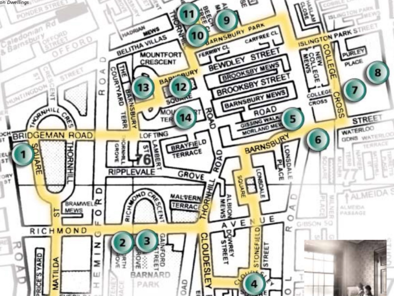
CANONBURY to BARNSBURY and on to CHAPEL MARKET and ANGEL

HIGHBURY & ISLINGTON Sta

VICTORIA LINE
LONDON OVERGROUND

NATIONAL RAIL

Heritage trail
Upper ST.
Islington Park St.
Before 1938 PARK STREET.
This was originally 1835 Kettle Lane, then Stewards Lane and known as Park Lane on a map of 1806, then later Park
Street.
In Kettle Lane lived Mary Hays (17601843) during the last years of the 18th and the early part of the 19th centuries.
George Dyer, the poet, who visited Lamb introduced her to the editor of the Critical Review and she wrote a novel,
also Female Biography and Memoirs of Queens, Illustrious and Celebrated.
Liverpool St.
Barnsbury Park
Barnsbury Park was developed in the 1820’s, and featured several large houses. Most are now
demolished but a few still stand, including no. 9. When first built, this was the home of the Rev. Daniel
Wilson, vicar of St. Mary’s, Upper St. In the 1920’s the artist Walter Sickert lived there with his wife,
painter Therese Lessore. If you walk into Beech Tree Close, or look behind no. 9, you can see the remains
of a Victorian industrial chimney, as there were once small industries in the area.
Notice the ‘Barnsbury Beech’, named by ‘Trees for London’ in 1997 as a particularly old and magnificent specimen!
Thornhill Houses were built in 1902 on the site of 10 Barnsbury Park
Thornhill Road. No. 45 was once the vicarage for Holy Trinity church, Cloudesley Square.

Alternative route
Bewdley St.

Before then, from 1824-1934 UPPER PARK STREET.
Bewdley is in North Worcestershire. Nos 44-46 built by Samuel Dallman.
ASHLEY HOUSE was there 1902-78. DOVEY LODGE (33-39) is a name dating from 1961.

Barnsbury Sq.
In many ways this is one of the most historic of
Islington squares as for many years it was believed to be the site of a Roman moated fort. However, the
moat probably only belonged to a medieval farm.
The square was developed in the 1830’s; in one corner lies the picturesque Mountford Crescent, with
pairs of grand stuccoed houses and a single house, once St. Andrews vicarage. Further round is
Mountford House, built on the moat site. After grand beginnings, from 1896 it was run as a ‘home
for destitute boys’ for several years. The square declined and Mica House, now apartments, was one of
several buildings for light industry built in Mountford House’ grounds in the 1930’s.
In the 18th and 19th centuries, the area to the west of the current square was widely described as being the site of an ancient Roman camp used by the Roman governor of Britain, Gaius Suetonius Paulinus, before defeating queen Boudica(Boadicea) of the British Iceni tribe at Battle Bridge (now Kings Cross) in AD 61.[1]: 2–5 [2][3]: 129–130 [4]: 44–49 However, this myth has no archaeological foundation, and most historians now favour potential sites in The Midlands for the decisive battle. The ancient earthworks of the Barnsbury site, which were built over in the 1930s, were probably the remains of the fosse of a medieval manor house belonging to Barnsbury Manor
instead being a central space with disparate single and paired villas on three sides.[9]: 142 No side is the same as another. Development of the area known then as “Pond Field” began in the 1820s, starting with Minerva Terrace (62-82 Thornhill Road) in 1827
The first reference to “Barnesbury Square” was in 1834, and the substantial small mansion named Mountfort House was built the next year on the west side, its rear garden including the old earthworks. Mountfort Crescent, containing two pairs of bow-fronted semi-detached houses and a single bow-fronted house, was begun around 1837, also on the west side. The north and south sides of the square were built probably starting in 1837, in a variety of styles
As Barnsbury’s prosperity declined in the late 19th century, housing and light industrial development filled in many open spaces. Mountfort House was converted to industrial use, a workshop built on its north side, and its garden built over by a factory building, Mica House. In the 20th century, two villas on the north side were destroyed in the Blitz and replaced by six low-rise houses.[4]: 32
In recent years, Mountfort House and Mica House have been restored and converted to private dwellings, and the workshop replaced by a modern, glass, apartment and office building
The best-known inhabitants of the square were the Forbes-Robertson family, including Sir Johnston Forbes-Robertson, eminent Shakespearean actor, who spent much of his childhood at Mountfort House between 1859 and 1874.[4]: 31 His siblings also lived there, including the novelist Frances, the actors Ian and Norman, and the painter Eric Forbes-Robertson. Their father John was a successful journalist and art critic, and famous visitors to Mountfort House at this time were artists and writers, including Algernon Swinburne, Dante Gabriel Rossetti, Marie Spartali, Ford Madox Brown, William and Jane Morris, Lawrence Alma-Tadema, William Hamo Thornycroft, Arthur Hughes and George MacDonald

Lofting Road

Nearby
Site of the NORTH LONDON or BARNSBURY SYNAGOGUE
Between the 1840’s and 1860’s, Barnsbury became a popular area for the affluent Jewish community with more than 1,000 people moving from the City and East London. However, by the 1880’s, with Barnsbury in decline, most of the community had moved to Highbury, Canonbury and Mildmay. The Barnsbury Synagogue closed in 1958.
Bridgeman Road
THORNHILL ESTATE. From dairy farming to gentrification
The extensive Thornhill Estate in Barnsbury was owned by the wealthy Thornhill family, originally from Yorkshire, who had acquired a substantial amount of land in the area which was primarily let for dairy farming. Several plans were drawn up between 1810 and 1847 for housing development on the estate, but little progress was made until the 1830s, under the ownership of George Thornhill. Construction of Thornhill Square by builders G.S.S. Williams & Son commenced around 1847, starting on the west side. A rich local dairy farmer, Samuel Pocock, built Thornhill Crescent starting around 1849.
Residents of the new estate were well-to-do, including lawyers, doctors, merchants and retired clergy.
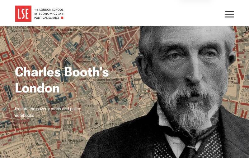
Charles Booth’s poverty map of c.1890 shows Thornhill Square households as “Middle-class. Well to-do”, and those of Thornhill Crescent as "Fairly comfortable. Good ordinary earnings".[6] However as the 20th century progressed, the area became run-down like much of Islington.
The Thornhill family interest ceased with the death of Captain Noel Thornhill in 1955, and there were rumours that the estate might be broken up and redeveloped. By 1959 about a third of the property in the surrounding square mile was condemned for rebuilding by Islington Council, and the vicar claimed that women were afraid to attend church on dark evenings because of the disagreeable neighbourhood.[1]: 142 However, as the area became newly fashionable as part of the gentrification of Islington in the 1960s and 1970s, many of the freeholds were privately purchased by occupants and the houses were rehabilitated. It was one of the later areas of Barnsbury to be reclaimed and rehabilitated.
ST.ANDREW’s THORNHILL SQUARE Church
With the substantial growth in the population as a result of new housing, additional new churches were needed in Islington. The site for a church was donated in 1852 by George Thornhill, and the large church of St Andrew was built here in 1852-54, seating 1,650.[2] Thornhill also gave £500 towards the building costs, and Samuel Pocock gave £100 for the railings. Mr Wontner, builder of nearby Tibberton Square, gave £2.
After winning the design competition, the church design was completed by John Johnson and Francis B. Newman and it was built by Dove Brothers Ltd, who were a Barnsbury based construction company from 1781 to 1993.The church was consecrated in 1854 by the Bishop of London, Dr Charles Blomfield in the presence of the Lord Mayor of London and other City dignitaries, indicating the prosperous status of the estate and its new residents. The £6,500 cost exceeded the sum stated in the competition conditions and, on completion, debts of over £2,000 were still outstanding.
WEST ISLINGTON PUBLIC LIBRARY
In 1906 nos. 64 & 65 Thornhill Square were demolished to make way for a new library. Islington West Library was designed by Professor Arthur Beresford Pite, the architect of the south end of Burlington Arcade, was built by C. Dearing & Co., and opened in 1907. Part of the cost of the building was from the library fund of Andrew Carnegie
TERRACES
Thornhill Square is the largest square in Islington and was for many years one of its largest open spaces,[1]: 136 although for many years the gardens were open only to key-holders.[1]: 143 Thornhill Square together with Thornhill Crescent form an unusual large ovoid ellipse. The houses are grouped in series, with houses with paired square-headed windows punctuated with sets of three with single windows, with the result that triangular pediments are flanked by semi-circular ones.[7] The houses were built with conservatories at the rear, many of which remain.
Thornhill Crescent
From 1854 Thornhill College for Ladies, no. 1A Thornhill Crescent, offered a broad education, including French, drawing, and music, and preparation for university and public examinations. In 1884 there were 40 boarders and day pupils
Thornhill Square
No.60 EDITH GARRUD, SUFFRAGETTES BODYGUARD, lived here

Edith Garrud (1872–1971), gave training in JIU-JITtsu and the use of Indian club to "the Bodyguard", a suffragette unit to protect Emmeline Pankhurst.
The GARDENS
Originally Thornhill Square gardens were provided for the private use of the residents of the square, and in the early days were mainly better-off professional classes. The gardens were Islington's largest (though private) recreational space until Highbury Fields were acquired in the 1880s.
The railings enclosing the garden date from 1852, having survived removal in the Second World War when many garden squares lost their railings. This was supposedly to provide scrap metal for munitions, but there is some scepticism as to whether they were actually used for this purpose. Historical paint analysis of the railings has shown that when first installed, they were painted a patina green to mimic weathered bronze, a common theme of early Georgian architecture.
Captain Noel Thornhill donated the gardens to Islington Council in 1947 for public use, and in 1953 the gardens were re-designed and landscaped with formal flowerbeds and a children’s playground as part of the Council’s “Coronation Year” improvements.[1]: 143-144 Planting includes shrub borders, ornamental displays and rose beds, with paths, lawns and seating, and a mound to the north
Matilda St.
As with many of the local street names, this is
a Thornhill family name. On the left-hand side (lhs) of the street is a recent development, Bramwell
Mews. The courtyard echoes the original layout, as this space was never built on but was occupied by a
saw mill and industrial outbuildings. These Victorian remnants were only demolished in 1992.
Richmond Avenue
SPHINXES & OBELISKS?
They seré erected because of a fascination with all things Egyptian in the mid 19th century.
Richmond Crescent
Tony Blair and family home before 1997 election victory
Nos.76-86 GAINFORD TERRACE
These were the first houses to be developed on the Thornhill Estate. They were built in 1829.
THE ALBION P.H.
originally a tea-house, named after Thomas Albion Oldfield, who owned a local dairy and fields that were used for cricket matches
Detour for an enigmatic plaque
THE DRAPERS ARMS P.H.
The Drapers' Company inherited (left to the Worshipful Company of Drapersin 1690 by the daughter of John Walter, one of its former Clerks, for the support of almshouses in Southwark and Newington.[3][4]) land known as Gossey Field, or Gossyfield, in the 1600s. The area was originally farmed and then used as a cattle pen en route to Smithfield Market.
Between 1838 and 1842 the Drapers' Company laid out nearby Lonsdale Square - comprising distinctive Tudor style tall brick houses - as well as Barnsbury Street, including the pub. To this day the pub is leased from the Drapers' Company, one of London's twelve Livery Companies.
The building was described by Pevsner as a: 'set frontispiece with its eaves, brackets and window pediments'.
LONSDALE SQ.
bounded by unusual Tudor Gothic Revival terraced houses, with picturesque gables and Elizabethan-style windows, and is probably unique among squares. All the houses are listed buildings. The central public garden contains flower beds and mature trees.
In the 1830s the Drapers' Company joined the race to build in Islington, appointing as architect their own surveyor Richard Cromwell Carpenter, who was also district surveyor for East Islington.[4]: 118 Carpenter's father, also named Richard, had been the first Surveyor for the Drapers' Company Estate and had drawn up plans for pairs of classical houses on the site. His son became Company Surveyor after his father's death in 1839 and completed the scheme to his own design.Carpenter was a friend of Augustus Pugin, and built Gothic Revival churches and almshouses elsewhere, and De Beauvoir Square in Hackney, before his early death at the age of 42. Lonsdale Square was laid out in 1838, and built between about 1838 and 1845. Drawings for the square were exhibited at the 1841 Royal Academy exhibition.
The initial house leases stipulated single-family occupation, and the original occupants of the square were predominantly comfortable middle-class, with a third of them in 1851 being in religious orders, perhaps attracted by the ecclesiastical style of the buildings. Charles Booth’s poverty map of c.1890 shows most Lonsdale Square households as “Middle class. Well-to-do.”
As with most of Islington, the square's prosperity sank in the early 20th century, and the houses were let as furnished rooms in multiple occupation. The Drapers' Company auctioned the square in 1954 when it had become down-at-heel. In the 1960s the square, as with much of Islington, had a revival and its individual architectural style had great appeal to middle-class families. The houses were rehabilitated by owner-occupiers, with some converted to flats, and it became newly fashionable.
A curiosity…
The south-west corner only had a facade until the mid 1960s, when the space behind the facade was infilled by an ingeniously contrived building providing two maisonettes and a flat by Peter Foggo, one of the founders of Arup Associates. It was later converted into a single family house.
STILL MORE INFORMATION : https://en.wikipedia.org/wiki/Lonsdale_Square
MILNER GIBSON ESTATE
Thomas Milner Gibson was a Member of Parliament, President of the Board of Trade, supporter of the free-trade movement and a leading anti-Corn Laws orator.[2]: 124 In 1823 Milner Gibson leased land in Islington from local landowner William Tufnell, and his estate surveyor and architect Francis Edwards laid out an estate between 1828 and 1846.[3]: 88–89 [2]: 124 The plot formed Theberton Street, the two neighbouring squares Milner Square and Gibson Square,[4]: 57–69 and some smaller streets. On Edwards' original plans "Milner Square" and "Gibson Square" were at that point reversed.
MILNER SQ.
bounded by early Victorian terraced houses, which are all listed buildings. Historic Englanddescribes it as "important for the radical logic of its design, of a type rarely seen outside Scotland and the North, and unlike anything in London." The houses were designed by architects Robert Lewis Roumieu and Alexander Dick Gough,[5] and work began on the east side in 1841 and was completed in 1844. Roumieu's original plan included a large Greek-style church at the centre of the west side, 60 ft (18 m) wide, to accommodate a congregation of 1,000.[3]: 124 The church plan did not proceed, and the west side of the square was completed about 1850 as a copy of the east side.
The square was initially occupied by prosperous middle class tradesmen and professionals. As with much of Islington, in the middle and late 19th century Barnsbury was gradually abandoned by the middle classes who were replaced by poorer occupants. Starting in 1856, Islington's Medical Officer of Health Dr Edward Ballard published annual reports into public health in Islington, and noted unsanitary conditions in many locations with "mortality from tubercular diseases" and "zymotic mortality" in Milner Square from 1857.[6][7]: 259–260 Charles Booth’s poverty map of c.1890 still shows most Milner Square households as "Fairly comfortable. Good ordinary earnings".[8]
In the first half of the 20th century the square, as with much of Islington and its population, became impoverished. Between the world wars and for some time afterwards, houses were tenemented by absentee landlords and often let in single rooms, and by the 1950s the effect was of unrelieved gloom. The run down buildings were purchased by Islington Council in 1973 and restored and converted into council flats, completed in 1977 at a cost of £21⁄2 million.[9] Many of the square's previous inhabitants were relocated to housing estates and New Towns; their memories of life in the square were collected in a 2015 documentary film, Through The Hole In The Wall: Milner Square 1935-75
A secret passage…and an enigmatic graffiti
It looks like an enlarged, slightly blurred reproduction of a stamped document. The image includes the text "Sydney Airport," along with other illegible numbers or codes. It appears to represent a stamp placed in a passport upon arrival in Australia, dated 24 June 1964. The purpose of this piece is unknown, making it a local enigma.

Detour
Almeida St.
ALMEIDA THEATRE

Upper St.

GIBSON SQ.
has a distinctive appearance when compared to other Islington squares, with two identical long terraces east and west, facing each other, with pavilion blocks at the end of each. These terraces and the south (Theberton Street) terrace have central groups supporting a cornice, with the end groups having pediments and large, flat pilasters.[2]: 93 The north terrace appears slightly shifted westwards, due to the north eastern exit road to Milner Square.[9]: 26 In the north western exit, the corner building at the junction with Liverpool Road was burnt out in 1974,[10] and replaced in 1988 by a new building with an Egyptian and Art Decotheme.[2]: 95
The square is largely unchanged since its original construction, and many houses retain original interior features such as simple fireplaces, shutters, pine half-panelling, and folding doors between the downstairs parlours
Gardens
In 1963, when London Transport was building the new Victoria line of the London Underground, Gibson Square gardens were earmarked for a ventilation shaft, with a 50 feet (15 m) high ventilation tower clad in exposed aggregrate concrete panels. The new, articulate, and well-organised owner-occupiers formed a society to fight the proposal,[13] and after a lengthy campaign and with the support of Sir Basil Spence and Sir William Holford amongst others, the design was modified until the current solution was accepted. This is a neoclassical brick structure, with a pedimented temple front with niches and a dome-like mesh roof. It was designed by Raymond Erith, with Quinlan Terry. London Transport also restored the gardens, repaved the paths with York stone slabs, and replaced the chicken wire fencing with metal railings.
During the Second World War the gardens were dug up for air-raid shelters
Theberton St.

Detour to Upper St.
Theberton and Upper Streets: Shops and eateries
THE KING’S HEAD P.H.
ISLINGTON SQUARE. Former ROYAL MAIL post office and sorting office, now shops, eateries, public spaces, apartments and workspace

St.MARY’S ISLINGTON Parish Church
Over Liverpool Rd
Site of themCLOUDESLEY ESTATE
Richard Cloudesley, the owner of the Cloudesley estate in Barnsbury from the early 16th century, died in 1517. He seems to have feared posthumous difficulties, as contemporary sources at the time of his death describe him as being in a distressed state of mind, his body "restless, on the score of some sinne by him peradventure committed".
A "wondrous commotion" and "tremblements de terre" in the earth near his burial place at St Mary's Church, Islington were ended only after an exorcism "at dede of night, nothing lothe, using divers divine exercises at torche light, set at rest the unrulie spirit of the sayde Cloudesley, and the earthe did returne aneare to its pristine shape".[1]: 305 This was later related in an anonymous penny pamphlet of 1842 entitled The Islington Ghost!.
Cloudesley bequeathed 14 acres (5.7 ha)[Note 1] of land called the “Stony Fields” to the parish of St Mary's, asking that yearly forever a solemn obit (a mass for the dead) should be said for the repose of his soul. The land survived the Reformation unconfiscated, and was used as meadow or pasture for the next three centuries,
By 1811, the land had become more valuable as a site for housing during the building boom which was starting in Islington, and a private Act of that year enabled the trustees to grant 99-year building leases; building actually started with Cloudesley Terrace on Liverpool Road in 1818.
Subsequent construction on the long, narrow Stony Field site (also known as the Stonefield Estate or Cloudesley Estate) created Cloudesley Square, Cloudesley Road, Cloudesley Street, and Stonefield Street,[2]: 11 [7]: 138 with a mixture of third rate and fourth rate houses intended for single family occupation by middle class and professional residents, and tradesmen and skilled craftsmen.[4]: 35-36 Cloudesley Square was the earliest Barnsbury square to be built, in 1826–29, on a building lease taken by Pentonville carpenter John Emmett, father of architect John Thomas Emmett.
By 1895 the Cloudesley Charity's income from the estate consisted of ground rents from around 240 houses on leases which would fall in between 1899 and 1916. As with much of Islington at this time, houses built for single families became multi-occupation, with rooms rented cheaply. Barnsbury had become a crowded working-class neighbourhood. "The estate" it was said in 1937, "must now be considered as one which comprises tenement houses".[4]: 67 Most of the estate consisting the ground rents of 71 houses and 2 shops was auctioned in 1937. Maintenance costs still exceeded rents, and in the 1970s the trustees sold off several long leaseholds. With the return of middle class and professional residents from the 1960s, many of the houses are now owner-occupied and house values have soared.
CLOUDESLEY SQ.
HOLLY TRINITY Church
designed by the young Charles Barry, best known for his role in the rebuilding of the Palace of Westminster (also known as the Houses of Parliament). The church is one of three in Islington designed by Barry,[12]: 654 commissioned by the Church Building Commissioners, the others being St John's, Holloway,[12]: 656 and St Paul's, Ball's Pond Road.[12]: 658 It was designed in the newly fashionable Perpendicular style and recognisably copies King’s College Chapel, Cambridge in brick.
declared redundant in 1978[13] and remained empty until 1980 when it was leased by a Nigerian Pentecostal community, the Celestial Church of Christ. Possession was returned to the Diocese of London in 2018, for restoration and re-opening as a community resource to be known as the Cloudesley Centre.
Cloudesley Rd.
COMMERCIAL PAST: https://www.cloudesleyassociation.org/cloudesley-road-hunting-ghosts
Cloudesley St.
Former SCHOOL
is a Gothic Revival former parish infant school, completed in 1830.
CULPEPPER COMMUNITY GARDEN
established in the early 1980s on derelict land that was previously part of a densely populated Victorian slum area
. The site was transformed by local residents from a cleared, abandoned site into a popular community green space and nature reserve, surviving plans to develop it for housing.
Tolpuddle St.
On April 21, 1834, up to 100,000 people gathered at Copenhagen Fields in London for a massive demonstration to protest the unjust sentencing of the Tolpuddle Martyrs. Organized by trade unions, this march aimed to secure the pardon of six Dorset agricultural labourers transported to Australia for forming a union.
Key Facts about the Copenhagen Fields Demonstration:
- The Protest: The gathering was a direct response to the conviction of the six farm workers (George Loveless, James Loveless, Thomas Standfield, John Standfield, James Brine, and James Hammett) who were sentenced to seven years of transportation for taking an "unlawful oath" when forming their union.
- The Crowd: As many as 100,000 people met in what is now the Kings Cross/Islington area of London.
- The Petition: A "Monster Petition" with over 200,000 to 250,000 signatures was carried on a wagon to Parliament to demand the release of the men.
- Result: Although the government initially refused to accept the petition, the widespread public outrage and intense pressure forced a conditional pardon by June 1835, with full pardons granted by March 1836.
- Significance: The protest is recognized as a pivotal moment in the history of British trade unionism and popular, peaceful protest.
Legacy of the Site:
- Location: Copenhagen Fields was a large open space located in Islington, north of King’s Cross Station, which was often used for mass gatherings in the 19th century.
- Commemoration: A 1984 mural painted by Dave Bangs, located off Copenhagen Street near Edward Square, commemorates the 1834 march.
- 2009 Event: The 175th anniversary of the event was celebrated with a new plaque and a march.
TOLPUDDLE, A DORSET VILLAGE: https://www.tolpuddlemartyrs.org.uk
Chapel Market (street)
The historic, traditional street market serving the local community for over 150 years, officially designated in 1879. Located near Angel station, it became a bustling hub for butchers and vendors by the 1880s, and is notably the site where Sainsbury's opened its first branch in 1882.
- Establishment: The market emerged in the 1860s to serve the growing population, formally recognized in 1879.
- Retail History: By 1881, the area boasted 31 shops and 150 barrows. It was a significant commercial location, featuring the first Sainsbury's branch at number 48.
- Iconic Stores: F. W. Woolworth & Co. opened a store here in 1929at Nos 40-42, noted for its neo-Georgian front.
- Cultural Significance: It is known as the "heart of the Angel". The market was also featured in the filming of the Only Fools and HorsesTV series.
Liverpool St.
ANGEL CENTRAL Shopping Centre
https://angelcentral.co.uk
Broomfield St.
Parkfield St.
Former ROYAL AGRICULTURAL HALL
Over Upper St.
Camden Passage and Islington High St.


I hope you are enjoying this guide


Create Your Own Website With Webador